
We’ve picked out 10 fantastic walks in Cairngorms National Park
With the second-highest mountain in the UK and more than 4,528 square kilometres to cover, the Cairngorms National Park is waiting to be explored on foot. Strap on your walking boots, grab your map and try one of these great walking routes:
There are two options of map; OS Explorer has a scale of 1:25 000 and OS Landranger has a scale of 1:50 000. OS Explorer is more zoomed in and offers greater detail and information, but the OS Landranger covers a greater area
If you’re planning you’re own route, but you’re not sure which map you need, then check out our Ordnance Survey online map finder here!
1.The Pass Of Ryvoan

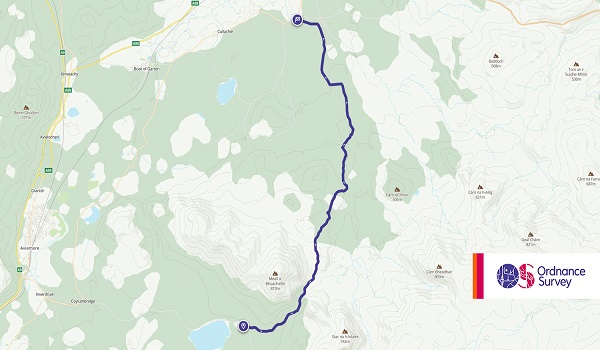
Climbing up to 380-feet, the Pass of Ryvoan takes you on a trip through beautiful pine Caledonian woodland with some stunning views out over the national park. Lasting around four to five hours (depending on your ability) this 9-mile hike is suitable for sure-footed adults armed with plenty of waterproof clothing and suitable walking boots so that you’re prepared for anything. Take a packed lunch with you if you’re venturing out in the morning, or stop off at a quiet café along the way. You may even spot some of the local wildlife if you’re lucky!
- Grade: Easy
- Terrain: Woodland, Open
- Distance: 15.50 km | Approx. Time: 4:10 hours (one-way)
Maps to purchase for this route: OS Explorer OL57: Cairn Gorm & Aviemore / OS Landranger 36: Grantown & Aviemore
You can download the route for this walk here.
2. Badenoch Way: Dalraddy to Ruthven


With plenty of local wildlife roaming freely, numerous munros in the region and some breathtaking scenery; the Badenoch Way is one of the most popular routes for walkers in the Cairngorms National Park. Taking between five and six hours to complete (depending on ability), this 11-mile stretch between Dalraddy and Ruthven will take you through the moors and down to the lochs, enabling you to see the REAL Scotland. Pack your walking boots and a picnic, because it’s worth stopping along the way to enjoy the views.
- Grade: Easy
- Terrain: Woodland, Open
- Distance: 16.70 km | Approx. Time: 4:35 hours (one-way)
Maps to purchase for this route: OS Explorer OL56: Badenoch & Upper Strathspey / OS Landranger 35: Kingussie & Monadhliath Mountains
You can download the route for this walk here.
3. Kingussie and Newtonmore (via Loch Gynack)


Loch Gynack is a must-see part of the Cairngorms National Park, so walking between Kingussie and Newtonmore gives you the ideal opportunity to take it in. The beautiful clear water of the Loch has made it one of the most photogenic features, and the walk itself isn’t too bad either! One of the relatively shorter routes covering 7-miles and taking experienced walkers between two and three-hours, it’s perfect for those who enjoy setting off for a hike in the morning and relaxing in the afternoon at your destination – or stopping off along the way for lunch! (Make sure you check what’s open online before you go, so you’re not relying on cafés etc when they may be closed due to Covid-19 restrictions)
- Grade: Easy
- Terrain: Open
- Distance: 8.30 km | Approx. Time: 2:25 hours (one-way)
Maps to purchase for this route: OS Explorer OL56: Badenoch & Upper Strathspey / OS Landranger 35: Kingussie & Monadhliath Mountains
You can download the route for this walk here.
4. Ben Macdui and Cairngorm

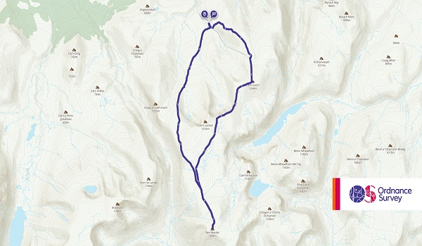
No trip to the Cairngorm National Park is complete without attempting to reach the summit of the two most iconic peaks in the region. Ben Macdui is the second-highest peak in the whole of the UK, behind Ben Nevis, and it is well worth the hours spent trekking to the top for the incredible views over the region. Similarly, the Cairngorm mountain is a highlight and key feature of the park. The ascents take around six to eight-hours depending on your experience and ability, covering almost 11-miles from the starting point at the ski centre.
- Grade: Moderate
- Terrain: Open, Mountain
- Distance: 17.84 km | Approx. Time: 6:05 hours
Maps to purchase for this route: OS Explorer OL57: Cairn Gorm & Aviemore / OS Landranger 36: Grantown & Aviemore
You can download the route for this walk here.
5. The Morrone Ascent, Braemar


For less experienced or less capable walkers, the Morrone Ascent is one of the best walks in the region. A relatively straightforward ascent in good conditions, this moderate difficulty walk takes up to five hours to complete and spans approximately seven and a half miles. The route itself is good, and the majority is paved making it a viable option for those with walking difficulties who still love to get out exploring. Having reached the summit you’ll find staggering views out over the national park, along with a section alongside the river on your way up (or down, depending on your route of course!)
- Grade: Moderate
- Terrain: Open, Hill
- Distance: 11.95 km | Approx. Time: 3:55 hours
Maps to purchase for this route: OS Explorer OL52: Glen Shee & Braemar / OS Landranger 43: Braemar & Blair Atholl
You can download the route for this walk here.
6. Speyside Way: Buckie to Fochabers


The Speyside Way is one of the most iconic parts of the Cairngorms National Park. Opening in 1981, the section between Buckie and Fochabers takes in some picturesque scenery along the coast before moving inland towards the mountains. Spanning 11-miles and taking a competent walker around four to five hours to complete, hikers can tackle a combination of coastal paths made from gravel and more typical woodland trails. The Speyside Way itself covers a total of 93-miles, meaning that the section from Buckie to Fochabers is a great way to sample it before moving onto a larger challenge.
- Grade: Easy
- Terrain: Open, Coastal
- Distance: 16.40 km | Approx. Time: 4:10 hours (one-way)
Maps to purchase for this route: OS Explorer 424: Buckie & Keith / OS Landranger 28: Elgin & Dufftown
You can download the route for this walk here.
7. Cateran Trail: Alyth to Blairgowrie (via the Bridge of Cally)


The Cateran Trail is one that you’re likely to see signposted throughout the national park. Covering a total of 63-miles in one large loop, the route goes from high to low – and back again! The section from Alyth to Blairgowrie is a challenging section that takes in the wonderful Bridge of Cally during the 15-mile moderate walk. Taking between six and seven hours to complete, this section of the trail is popular among keen and amateur walkers alike.
- Grade: Moderate
- Terrain: Open
- Distance: 24.45 km | Approx. Time: 7:10 hours (one-way)
Maps to purchase for this route: OS Explorer 381: Blairgowrie, Kirriemuir & Glamis / OS Landranger 53: Blairgowrie & Forest of Alyth
You can download the route for this walk here.
8. Dava Way: Grantown-on-Spey to Dava


The Dave Way is a beautiful route for those who love nothing more than a hike in the forest. With soft ground and plenty of sticks and potential hazards, it’s not a walking route suited to everybody, but the section between Grantown-on-Spey and Dava is made popular by its relatively short distance. The Dava Way itself would take several days to complete making it an excellent route for those looking to stop off in various towns and villages along the way, and the section covers 8.5-miles which is a good workout for any hiker.
- Grade: Easy
- Terrain: Open
- Distance: 12.55 km | Approx. Time: 3:20 hours (one-way)
Maps to purchase for this route: OS Explorer OL61: Grantown-on-Spey & Hills of Cromdale / OS Landranger 27: Nairn & Forres
You can download the route for this walk here.
9
9. The Glen Tilt Circuit – Blair Atholl


The Glen Tilt Circuit at Blair Atholl Estate is one that is definitely for the more experienced hikers due to the nature of the surface. Covering a total of 9.5-miles, the circuit takes you through beautiful woodland filled with local wildlife including roe deer and red squirrels. The gravel tracks and forest trails mean that the surface is uneven and rutted in places so you’ll have to keep your eye on the route as well as the scenery! There’s even a river crossing near the end so be sure to pack your waterproofs (or find yourself a drier crossing point!)
- Grade: Easy
- Terrain: Open
- Distance: 14.70 km | Approx. Time: 4:20 hours
Maps to purchase for this route: OS Explorer OL51: Atholl / OS Landranger 43: Braemar & Blair Atholl
You can download the route for this walk here.
10. The Glenbuch at Ridge near Strathdon


Starting at the fabulous Glenbuchat Castle, this is another of the most iconic walks in the Cairngorms national park. Starting out at the Castle itself, the Glenbuchat Ridge near Strathdon covers a range of surfaces throughout the 8-mile walk. From soft farmland to gravel tracks up and down the hills, this three to four-hour walk is of a moderate difficulty meaning it’s a good one to get your teeth into when trying out a more complex walk for the first time.
- Grade: Easy
- Terrain: Open, Hill
- Distance: 17.20 km | Approx. Time: 5:05 hours
Maps to purchase for this walk: OS Explorer OL62: Correen Hills & Glenlivet / OS Landranger 37: Strathdon & Alford
You can download the route for this walk here.
If you ever visit Cairngorms National Park or happen to live nearby, then how about trying out one of these fantastic walks? Get your gear ready, soak up the Scottish scenery and observe the wildlife! The perfect day out!
Looking for more inspiration? Head to our blog to read more unbeatable content from us!
