
The mountains are calling!
We Brits love a challenge, and you don’t have to travel very far to put yourself to the test. There are plenty of mountains in the UK ready for you to conquer, and there’s something for every level of ability, so there are no excuses not to give it a go. Here we have collected 15 mountains around the UK that we think are must-climbs, from the big three to some slightly lesser climbed peaks that have a lot to offer.
If you do plan to tackle any mountain, make sure that you are properly kitted out to do so. Avoid ascents in trainers or weak footwear, always travel with plenty of time to get down before dark, and always prepare for varying weather types. Often the weather at the summit will be very different to the weather at the bottom! This is why having mutiple layers to ensure you’re prepared for all weather types is crucial. Check out our Layering System Guide to find out exactly how it works and what you will need!
There are two options of map; OS Explorer has a scale of 1:25 000 and OS Landranger has a scale of 1:50 000. OS Explorer is more zoomed in and offers greater detail and information, but the OS Landranger covers a greater area.
If you’re planning you’re own route, but you’re not sure which map you need, then check out our Ordnance Survey online map finder here!
1. Ben Nevis, Lochaber, Scotland


- Grade: Moderate
- Terrain: Mountain
- Distance: 15.35 km | Approx. Time: 6:45 hours
- Height: 1345m
We had to start this list with the tallest mountain in the British Isles, ‘The Ben’ as it’s affectionately named locally is the tallest mountain test you can take on in the UK. Near the small town of Fort William, Ben Nevis understandably attracts a lot of tourists. Most walkers tackle the ‘easier’ Mountain Track up the mountain, starting at Glen Nevis. There are other routes up the Ben, and experienced climbers are often attracted to the ‘North Face’, which is one of the highest cliffs in the UK. The summit of Ben Nevis is approximately 1345m above sea level.
Maps to purchase for this route: OS Explorer 392: Ben Nevis & Fort William / OS Landranger 41: Ben Nevis
You can download the route for this walk here.
Note: There are multiple route options for this mountain, this one is the Mountain Track.
2. Snowdon, Snowdonia , Wales


- Grade: Moderate
- Terrain: Mountain
- Distance: 14.40 km | Approx. Time: 5:40 hours
- Height: 1085m
The most popular mountain in the UK, Snowdon is the highest In Wales & England and attracts more visitors than any other mountain, well over 585,000 each year. There are a number of well-worn tracks to reach the summit of Snowdon, with the Llanberis Path being the most popular. Its popularity means that through summer, this mountain is very busy and with a railway to the top, and a visitor centre on the summit – it maybe doesn’t have the traditional summit feel that some of the mountains on this list have. That being said, you have to climb Snowdon at least once, as the view from the top was recently voted the most spectacular view in the UK.
Maps to purchase for this route:
OS Explorer OL17: Snowdon / Yr Wyddfa
OS Landranger 115: Snowdon/Yr Wyddfa
You can download the route for this walk here.
Note: Multiple route options, this one is the Llanberis Path.
3. Scafell Pike, Lake District, England


- Grade: Moderate
- Terrain: Mountain
- Distance: 11.50 km | Approx. Time: 4:55 hours
- Height: 978m
The highest peak in England, Scafell Pike along with Snowdon and Ben Nevis make up the Three Peak Challenge. At 978m, the summit of Scafell is the highest point for over 90 miles around and on a clear day offers far reaching views to Wales, Scotland, and Ireland – if you’re lucky enough to get a crisp clear day. Scafell Pike is the home to the highest standing water in England, known as Broad Crag Tarn. Unlike it’s taller counterparts, there are no buildings at the top of Scafell Pike. A number of routes will take you to the top, for varying degrees of experience, the quickest route being roughly 2-3 hours.
Maps to purchase for this route: OS Explorer OL06: English Lakes – South-western area / OS Landranger 90: Penrith & Keswick
You can download the route for this walk here.
Note: Multiple route options, this one is the Corridor Route
4. Tryfan, Snowdonia, Wales


- Grade: Difficult
- Terrain: Mountain
- Distance: 6.50 km | Approx. Time: 3:10 hours
- Height: 917m
According to Trail Magazine a few years ago, Tryfan won their public vote for Britain’s favourite mountain. Although it’s only the 15th tallest in Wales, this favourite has a lot to offer. It’s a distinctive and easily recognisable place, with it’s pointed top looking like a fin made of three ridges. Tryfan is considered a line between rambling and mountaineering, as the closer to the top you get, you will need to use your hands and feet to reach the summit. Not for the faint of heart, or the unfit, Tryan can be dangerous if not properly respected. The most popular route to the top is the North Ridge.
Maps to purchase for this route:
OS Explorer OL17: Snowdon / Yr Wyddfa
OS Landranger 115: Snowdon/Yr Wyddfa
You can download the route for this walk here.
Note: Multiple route options, this one is the North Ridge Route.
5. Slieve Donard, County Down, Northern Ireland


- Grade: Difficult
- Terrain: Mountain, Woodland
- Distance: 9.50 km | Approx. Time: 4:10 hours
- Height: 850m
The highest peak in Northern Ireland, Slieve Donard sits within the picturesque Mourne Mountains. Points of interest on your ascent include the Mourne Wall, a wall which crosses over 15 mountains in the Mournes. At the summit, you’ll find the remains of the Great Cairn, which is said to be a Neolithic Passage Tomb, the highest of it’s kind in Britain and Ireland.
You can download the route for this walk here.
6. Helvellyn, Lake District, England


- Grade: Difficult
- Terrain: Mountain
- Distance: 11.20 km | Approx. Time: 4:50 hours
- Height: 950m
The third biggest mountain in England, Helvellyn may be some way down the scale for height, but this Lake District mountain is certainly one of the most popular due to it’s ease of access. On your ascent of Helvellyn you’ll find glacial coves and the sharp ridges of Swirral Edge and the famous Striding Edge. There are a number of routes up Helvellyn for varying degrees of experience, but the stunning Lake District views from the top on a clear day are always worth it. For more experienced walkers and those looking for a more challenging ascent, take the route which includes Striding Edge, which features an element of scrambling, as with any ridge walk, Striding Edge demands your full attention and respect, as it can be dangerous if taken lightly.
Here we are offering two different routes which you can try if you want to hike up Helvellyn:
6a. Helvellyn via Lower Man and Browncove Crags, Lake District, England
Maps to purchase for this route: OS Explorer OL05: English Lakes – North-eastern area / OS Landranger 90: Penrith & Keswick
You can download the route for this walk here.
6b. Helvellyn via Striding Edge and Swirral Edge, Lake District, England
Maps to purchase for this route: OS Explorer OL05: English Lakes – North-eastern area / OS Landranger 90: Penrith & Keswick
You can download the route for this walk here.
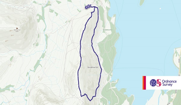
7. Ben Macdui, Cairngorms, Scotland


- Grade: Difficult
- Terrain: Mountain
- Distance: 29.35 km | Approx. Time: 10 hours
- Height: 1309m
The second highest mountain in the UK, Ben Macdui is the highest point in the Cairngorms and is a much wilder experience than it’s bigger brother Ben Nevis. If we told you that this mountain was near the Cairngorm Ski Centre, you’d probably be able to guess that this mountain sees a lot of freezing weather and snow in the winter months. To add to the mystique of Ben Macdui, the summit of the mountain is said to be haunted by the ‘Big Grey Man‘, which over time has been sighted as an actual large grey figure, but more commonly is felt as an uncomfortable feeling of worry and panic.
Maps to purchase for this route: OS Explorer OL57: Cairn Gorm & Aviemore / OS Landranger 43: Braemar & Blair Atholl
Note: Multiple route options, this one starts at the Linn of Dee
8. Pen y Fan, Brecon Beacons, Wales


- Grade: Easy
- Terrain: Mountain
- Distance: 7.40 km | Approx. Time: 3 hours
- Height: 886m
Pen y Fan and it’s twin mountain Corn Du are the highest peaks in Brecon Beacons National Park and South Wales. Pen y Fan is a popular climb due to having well-made paths all the way to the summit, making it a great mountain for most to climb. The mountain is also part of the Beacons Way, which to complete you’d have to go up both Pen y Fan and Corn Du. The most popular route up and down the mountain begins near the Storey Arms activity/education centre.
Maps to purhcase for this route:
OS Explorer OL12: Brecon Beacons National Park / Parc Cenedlaethol Bannau Brycheiniog
OS Landranger 160: Breacon Beacons/Bannau Brycheiniog
You can download the route for this walk here.
Note: Multiple route options, this one via Corn Du
9. Great Gable, Lake District, England


- Grade: Moderate
- Terrain: Mountain
- Distance: 8.65 km | Approx. Time: 3:55 hours
- Height: 899m
One of the most popular of the Lake District peaks, Great Gable is centrally placed in the National Park. The mountain has a unique trait of looking like a large pyramid when viewed from the village of Wasdale (it’s top looks rounded from most other angles). Ascents can be made from most angles on Great Gable, depending on what you want to see and achieve from your walk. Its position in the Lakes gives it beautiful panoramic views of the whole area. The summit of Great Gable is strewn with a number of boulders, and it’s highest point marked with a rock outcrop. Great Gable has some steep ascents near the top and will involve some scrambling, a real climbers mountain.
Maps to purchase for this route: OS Explorer OL06: English Lakes – South-western area / OS Landranger 90: Penrith & Keswick
You can download the route for this walk here.
Note: Multiple route options, this one is via Wasdale Head
10. Buachaille Etive Mor, Highlands, Scotland


- Grade: Difficult
- Terrain: Mountain
- Distance: 14.10 km | Approx. Time: 6 hours
- Height: 1,021m
We had to include Buachaille Etive Mor, or the Buachaille as it’s more affectionately known. You may have noticed that the images of the other mountains have been views of or from the summit, but this mountain is known for it’s look from the bottom. One of the most photographed locations in Scotland, the Buachaille looks like a mountain that a child would draw if you asked them to draw a mountain. Its steep pyramid shape makes it look unclimbable, and this climb isn’t for the inexperienced. The routes are steep, and it will involve some scrambling and care with climbing. That being said this is truly one of the more beloved Munros, and it’s certainly one to tick off for seasoned climbers.
Maps to purchase for this route: OS Explorer 384: Glen Coe & Glen Etive / OS Landranger 41: Ben Nevis
You can download the route for this walk here.
11. Cadair Idris, Gwynedd, Wales


- Grade: Difficult
- Terrain: Mountain
- Distance: 8.84 km | Approx. Time: 3:40 hours
- Height: 893m
Cadair Idris is a real favourite for those who have climbed it, it’s not as busy as the more popular mountains in Snowdonia, but the glacial carved scenery is beautiful and not to be missed. There are three main routes to the summit: Pony Path, Foxs Path and Minffordd Path. The ascent is a challenge due to being relentlessly uphill (it’s a mountain, but what we mean is that it’s steep on the paths) so an element of fitness is required.
Cadair Idris comes with it’s own set of myths and legends, it’s name derives from ‘Chair of Idris’, Idris according to Welsh legend was a giant warrior poet who created this seat to gaze upon the heavens. If a giant warrior poet wasn’t enough, some say Cadair Idris is the hunting ground of Gwyn ap Nudd, Lord of the Celtic Underworld ‘Annwn’ who is accompanied by his supernatural red-eared hounds while they herd people’s souls back to the underworld. Llyn Cau, the stunning picturesque lake on the mountain, is said to be a bottomless lake that is home to a Welsh water dragon. The dragon once used to terrorise villagers until King Arthur captured it and dragged it up the mountain to imprison it in Llyn Cau.
Maps to purchase for this route: OS Explorer OL23: Cadair Idris & Llyn Tegid / OS Landranger 124: Porthmadog & Dolgellau
You can download the route for this walk here.
12. Pen y Ghent, Yorkshire Dales, England


- Grade: Moderate
- Terrain: Mountain
- Distance: 10.35 km | Approx. Time: 4:15 hours
- Height: 694m
Looking to get started with a mountain? Pen y Ghent is a great ‘beginners’ mountain. The smallest the of the Yorkshire 3 peaks (The other two in the area are Whernside and Ingleborough). On your ascent of Pen y Ghent, it’s worth looking out for Hunt Pot and Hull Pot, both popular with cavers, these large fissures have been carved out by the running water on the mountain. If you’re climbing in wet weather, then watch out for the waterfall created at Hull Pot. Pen y Ghent is a nice mountain to get you started, or to be taken in as part of the Yorkshire 3 Peaks challenge.
Maps to purchase for this route: OS Explorer OL49: Pitlochry & Loch Tummel / OS Landranger 51: Loch Tay & Glen Dochart
You can download the route for this walk here.
13. Schiehallion, Perth & Kinross, Scotland


- Grade: Easy
- Terrain: Mountain
- Distance: 6.3 km | Approx. Time: 3:40 hours
- Height: 1083m
One of the most accessible Munros, and popular with walkers. A new footpath was laid on the mountain by the John Muir Trust within the last 20 years, better able to handle the ammount of visitors that it attracts yearly. From the summit, on a clear day, you’ll be able to see Ben Nevis in the distance, but closer by it offers stunning views over Loch Rannoch. It has a good path most of the way up, so although it’s tall, it’s not as difficult as some of the mountains on the list.
In an interesting fact, the mountain’s isolated location and symmetrical shape made it the subject of an 18th century experiment to estimate the weight of the world. This was known as the Schiehallion experiment.
Maps to purchase for this route: OS Explorer OL38: Loch Lomond South / OS Landranger 56: Loch Lomond & Inveraray
You can download the route for this walk here.
14. Catbells, Lake District, England

- Grade: Moderate
- Terrain: Mountain
- Distance: 5.20km | Approx. Time: 2:15 hours
- Height: 451m
For us and many, Catbells is the ultimate starter mountain. It’s the ideal peak to introduce your kids to mountains. At just 451m it may not appeal to the hardened mountaineer, but everybody has to safely start somewhere, the summit still offers beautiful Derwent Water views and some thrilling mini scrambles that younger climbers will love. Beatrix Potter was a famous fan of Cat Bells, writing many of her famed stories based in the areas around Cat Bells, with Mrs Tiggywinkle said to have lived behind a tiny door on Cat Bells itself.
Maps to purchase for this route: OS Explorer OL04: English Lakes – North-western area / OS Landranger 90: Penrith & Keswick
You can download the route for this walk here.
15. Ben Lomond, Loch Lomond & Trossachs, Scotland


- Grade: Easy
- Terrain: Mountain
- Distance: 6.3 km | Approx. Time: 3:40 hours
- Height: 974m
How can you make the stunning scenery of Loch Lomond even better? Climb the nearest mountain and enjoy the view from above. Another very popular Munro due to it being in a high traffic area of the Highlands, Ben Lomond has a well-worn and relatively easy tourist path. The relative ease of the ascent doesn’t mean you shouldn’t be prepared, as inexperienced walkers can easily get lost in poor weather conditions.
Maps to purchase for this route: OS Explorer OL02: Yorkshire Dales – Southern & Western areas / OS Landranger 98: Wensleydale & Upper Wharfedale
You can download the route for this walk here.
These are just 15 of the hundreds of mountains around the UK. There is so much out there to discover, so we highly recommend brushing up on your map reading skills and heading out! Whether you’re trying the Yorkshire 3 peaks, the National 3 Peaks, or setting out on a long-term goal like Munro Bagging, the mountains are an amazing journey of discovery, challenge and reward.
The MOST IMPORTANT thing to remember before climbing any mountain at any time of year is to travel prepared. Check out our blogs for tips on packing your rucksack and what to take:
Plus, always make sure you check the Met Office Mountain Forecast for weather updates. It’s important to remember that weather in the mountains is changeable, and what you’re experiencing at the bottom, will be very different to what you’re experiencing at the top.
For further advice and information on mountain safety, click here.
